3 min read
How to Prepare for the Housing Rebound
After the pandemic-fueled buying spree that led to the most powerful U.S. housing boom in 15 years, the demand for housing has slowed as mortgage...

3 min read

Despite an increase of 77% from last year, the number of lots available for residential building in the US remains “significantly undersupplied”, according to the second quarter New Home Lot Supply Index (LSI) from Zonda.
The LSI is a residential real estate indicator based on the number of single-family vacant developed lots and the rate at which those lots are absorbed. An index value of 100 represents perfect equilibrium, while a value of 125 or above equals “significantly oversupplied” and a value of 75 or below equates to “significantly undersupplied”. Zonda ranks the current LSI at 63.4.
Overall, the tightest lot supply in major markets was found in Miami, San Diego, and Orlando. Boise, Idaho remains the highest market in the index at 103.9, an increase of 115% compared to last year.
As the housing demand continues to rise, the competition for acquiring lots is fierce. Zonda reported that 45% of builders are “full steam ahead” on land acquisition. Being able to quickly and accurately assess lots is critical for success. To combat this challenge and stay competitive, top builders and developers are turning to TraceAir.
TraceAir is a cutting-edge technology platform that is revolutionizing land development. By combining advanced aerial imagery with powerful, user-friendly tools and data, TraceAir enables homebuilders and developers to acquire lots faster and accelerate project schedules, giving them a major competitive advantage in the market.
Here’s how TraceAir makes it happen:
Accurately assessing property value, either for finished lots or raw land, can be a major challenge, especially for large and complex sites. Is every lot actually on grade, or will more grading need to be done? Are there stockpiles on site that need to be hauled off? Hills or valleys that need to be leveled or filled? This information is invaluable in determining property value, negotiations, due diligence, and project planning.
Relying on county surveys is a recipe for disaster - they are old, outdated, and unreliable. Using our national network of professional drone pilots, TraceAir provides you with valuable site data and high-resolution imagery within 24 hours of scanning the property. Most importantly, we give you data in a simple platform that you can actually use. No need to waste time driving to the site, wait weeks for aerial topos, or hire expensive consultants.
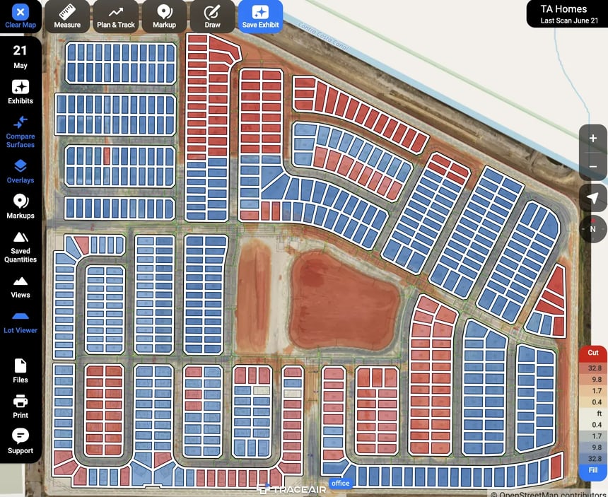
If you're buying finished lots, TraceAir’s Lot Viewer tool is an absolute game-changer. With one click, it breaks up your project into individual lots and calculates cut/fill balance and elevations. No other tool on the market can achieve such precise and comprehensive verification as quickly and easily as Lot Viewer.
We use Lot Viewer on every project. It has been a game-changing tool for helping us quickly assess our lots and track progress.”
— Ritchie Tan, P.E., Land Acquisitioner, D.R. Horton
The land entitlement process is complex, time-consuming, and costly due to the need for approvals from various government agencies at multiple levels. These agencies hold the authority to grant the crucial permissions to convert raw land into valuable, developable property.
Investors recognize that fully entitled property holds substantially higher value than undeveloped land. Therefore, allowing developers the necessary time and resources to navigate this process is crucial, as they are financially motivated to maximize the property's value.
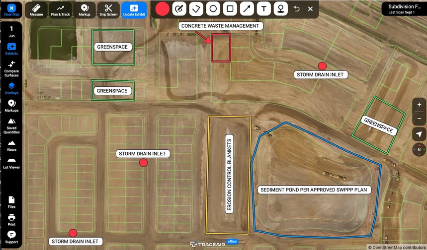
TraceAir revolutionizes the entitlement process through a multitude of innovative tools. Our overlays tool empowers you to strategically plan and optimize land usage, unlocking its full potential and ensuring compliance. Overlays help mitigate risk by making sure plans align with the land and as-builts. Additionally, our precision measuring tools provide the accuracy needed to meet greenspace, SWPPP, and various other compliance standards with confidence.
By providing unlimited licenses at no additional cost, TraceAir offers an unprecedented level of transparency. Developers, investors, engineers, and local authorities can collaborate and use TraceAir as a single source of truth. Furthermore, TraceAir facilitates effortless collaboration between land acquisition teams and land planning and development teams, ensuring alignment at every step.
This approach not only accelerates decision-making but also minimizes misunderstandings and maximizes the chances of successful land acquisition endeavors.
All the people I work with on my jobs, whether they're moving dirt or creating spreadsheets, absolutely love it. TraceAir elevates the communication and collaboration with everyone involved in the project, from investors and owners to contractors and engineers. The more communication you have on a project, the smoother the project will go.”
— PJ Stambaugh, Land Development Manager, Toll Brothers
Time is money, especially in the homebuilding industry. The faster you can acquire land and get through the entitlements process, the faster you can start building. With TraceAir, you not only speed up the entire project process through data-driven decision-making and enhanced efficiency, but also significantly reduce the risk of delays and errors, saving you valuable time and resources throughout your project's life cycle.
The reality is that regardless of the housing market, every homebuilder is actively trying to acquire more land. The growing demand for housing is not slowing down, and land prices will only continue to rise. Securing a competitive advantage for acquiring land is paramount for success. The only site intelligence software building specifically for homebuilders and land developers, TraceAir is that advantage.
By expediting land assessment and decision-making processes, reducing risk, and implementing seamless collaboration, TraceAir has earned its place as the #1 choice of top homebuilders.
To learn how TraceAir can empower your land acquisition and development teams, schedule a demo today.
3 min read
After the pandemic-fueled buying spree that led to the most powerful U.S. housing boom in 15 years, the demand for housing has slowed as mortgage...
3 min read
Are you experiencing staffing challenges? You’re not alone. Although the need for new buildings — such as residential homes, master-planned...

2 min read
Accurate original ground (OG) topography is the foundation for every successful land development project. Whether it’s budgeting, planning, or...