Complete site visibility.
From dirt to delivery.

The #1 site intelligence platform trusted by 17 of the top 20 U.S. builders. Turnkey drone intelligence for land acquisition, development, and construction teams.

Book a demo
Banner icon

Recipient of the National Association of Home Builders’ Best Software Solution 2024.

TraceAir construction team working in the fieldTraceAIr lot viewer screenLand development manager working at computer

+50 top homebuilding companies use TraceAir

Client Logo
Client Logo
Client Logo
Client Logo
Client Logo
Client Logo
Client Logo
Client Logo
Client Logo
Client Logo
All in one place

One platform. Every team. Every stage.

TraceAir empowers every role with the tools to streamline, track, and deliver successful construction projects.

Built to deliver

Why choose TraceAir?

TraceAir empowers every role with the tools to streamline, track, and deliver successful construction projects.

Icon

Save time at every stage

From land acquisition to final handover, streamline workflows with tools that eliminate delays and speed up decision-making.

Icon

Trust your data

Timely 3D scans and precise reports ensure you stay ahead of issues, avoid costly errors, and make informed decisions.

Icon

Collaborate seamlessly

Keep your team aligned with a centralized platform that makes sharing updates and tracking progress simple and effective.

Acquisition
Plan from the ground up

Land acquisition and pre-development

Ensure a smooth development process by evaluating feasibility, addressing environmental challenges, and uniting stakeholders for a shared vision.

Learn more
by 80%
saved cut preparation time
from 3+ hours to 30 minutes
reduce weekly planning
  • Visual scans / 360° panos
  • Collaboration tools
  • Planning tools (overlay)
  • Cut/fill tools
  • Lot viewer
  • LiDAR
  • Schedule
  • Utility Tracking
  • Dashboard
  • Projects portal
  • Historical Data
  • Stormwater reports
Development
TraceAir Land Development: Optimize Earthwork and Grading with Precision

Land development and site preparation

Learn how TraceAir's platform aids in earthwork tracking, grading verification, and dirt balance monitoring to enhance land development efficiency.

Learn more
Prevented balance issues
by cutting preparation time
by up to 8-10%
reduced capital loss
  • Visual scans / 360° panos
  • Collaboration tools
  • Planning tools (overlay)
  • Cut/fill tools
  • Lot viewer
  • LiDAR
  • Schedule
  • Utility Tracking
  • Dashboard
  • Projects portal
  • Historical Data
  • Stormwater reports
Vertical construction
TraceAir Vertical Construction: Enhance Project Visibility and Progress Tracking

Vertical construction management

Explore how TraceAir provides tools for progress tracking, project visibility, and stakeholder communication during vertical construction.

Learn more
Reduce delays
by remote progress tracking
Cut inspection time
with keeping projects on track
  • Visual scans / 360° panos
  • Collaboration tools
  • Planning tools (overlay)
  • Cut/fill tools
  • Lot viewer
  • LiDAR
  • Schedule
  • Utility Tracking
  • Dashboard
  • Projects portal
  • Historical Data
  • Stormwater reports
Handover
TraceAir Portfolio Oversight: Executive-Level Visibility Across Projects

Portfolio oversight and executive management

Understand how TraceAir's platform offers executives comprehensive oversight and visibility into multiple projects for informed decision-making.

Learn more
Smooth coordination
across regions with real-time data
Prevent capital loss
by gaining full portfolio oversight
  • Visual scans / 360° panos
  • Collaboration tools
  • Planning tools (overlay)
  • Cut/fill tools
  • Lot viewer
  • LiDAR
  • Schedule
  • Utility Tracking
  • Dashboard
  • Projects portal
  • Historical Data
  • Stormwater reports
Collaboration
TraceAir Sales Turnover: Seamless Transition and Investor Collaboration

Sales and investor collaboration

Learn how TraceAir ensures smooth sales turnover processes and enhances collaboration with investors through accurate site data and reporting.

Learn more
Timely home deliveries
with lot readiness tracking
Improve buyer communication
with sales on schedule
  • Visual scans / 360° panos
  • Collaboration tools
  • Planning tools (overlay)
  • Cut/fill tools
  • Lot viewer
  • LiDAR
  • Schedule
  • Utility Tracking
  • Dashboard
  • Projects portal
  • Historical Data
  • Stormwater reports
Hear from our clients

Accelerate your business

Discover all features that simplify workflows and drive success throughout your projects.

All case studies

“If you'd like to have a better understanding of your projects and ensure accountability, I highly recommend giving TraceAir a try! With TraceAir, you'll gain a comprehensive understanding of your entire project and enhance efficiency in managing time and resources. Our experience with TraceAir has been great, and we continue to find new ways to use it throughout our division to improve efficiency.”

Shaun Hofman,
Land Development Construction Coordinator, Mattamy Homes

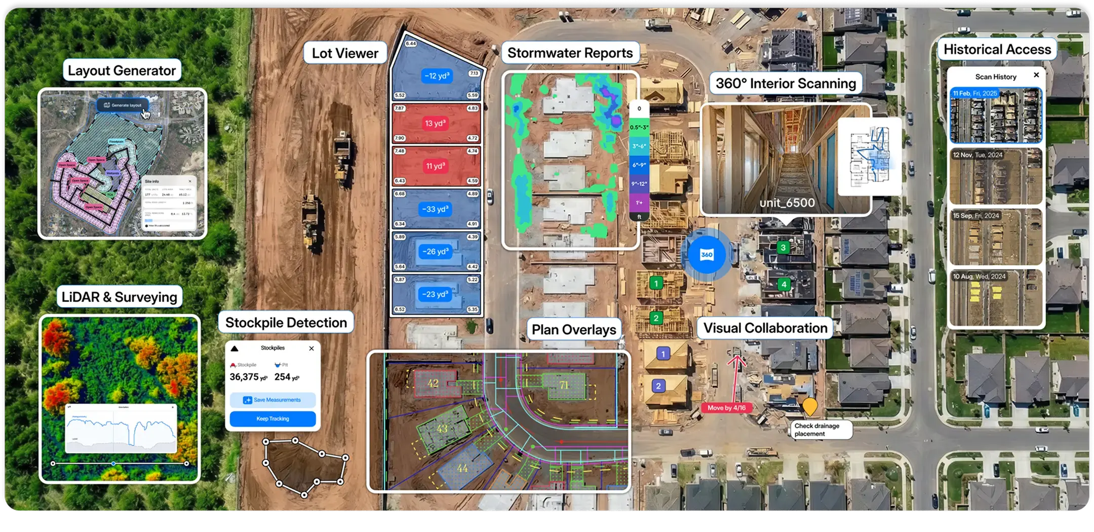
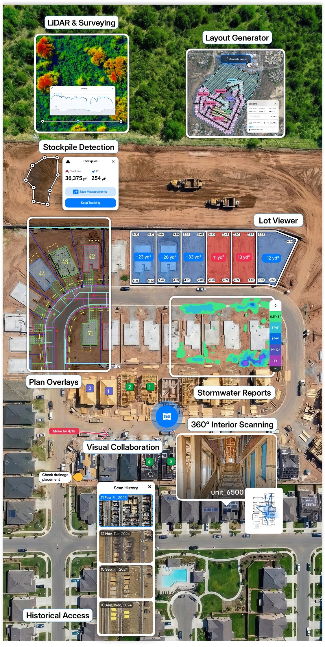
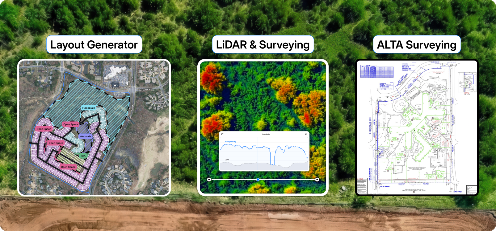
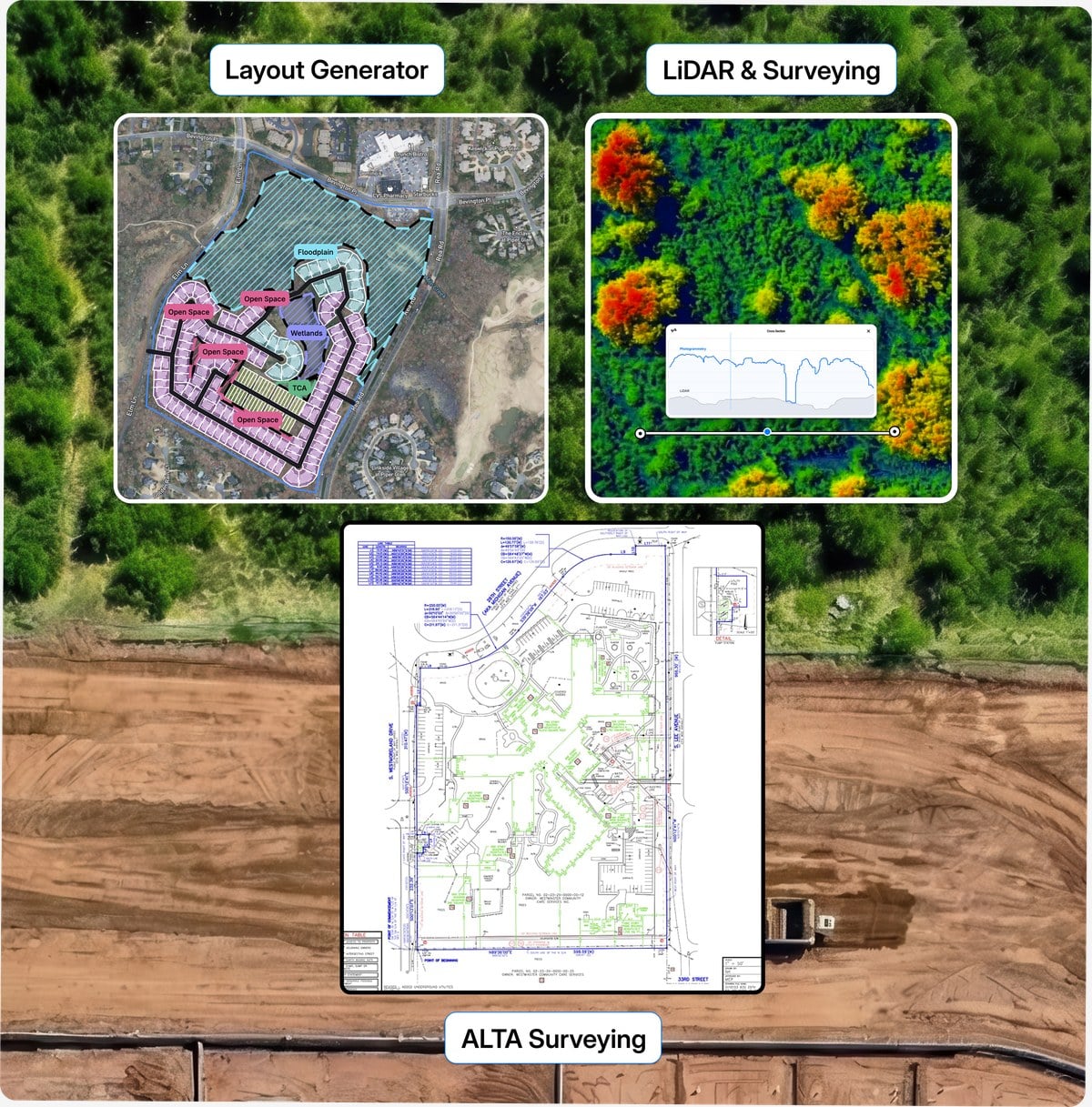
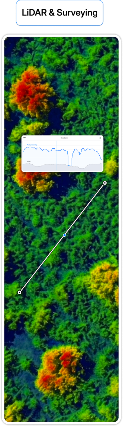
“Incorporating TraceAir into our processes has significantly enhanced our accuracy and efficiency. We can now assess earthwork needs more precisely from the beginning and throughout our projects. This improvement helps us account for necessary cut and fill needs, quickly identify and address discrepancies, and prevent delays and additional costs. Additionally, using TraceAir for tracking progress and quantities ensures the accuracy of the bills we receive.”

Brian Mangano,
Director of Regional Development at Brookfield’s Southern California Division

“I’d recommend TraceAir to anyone in land development—civil contractors, developers, builders. It’s a powerful, yet straightforward tool that helps you stay present on-site, save time, hold everyone accountable, and make informed decisions. TraceAir is a must-have for anyone in the industry. TraceAir really is a ground breaking, innovative way to develop.”

Cole Brooks,
Land Development Manager at Ashton Woods and Starlight Homes

“By replacing our previous methods with TraceAir, we save 30-40% on costs. The ROI in terms of time, money, and overall efficiency is tremendous. TraceAir is incredibly easy to use, especially for those who understand land development. It reduces the need for on-site surveyors, as we can log in and access the information we need. This makes a major difference in speed and accuracy.”

Kelly Dykes,
VP of Operations, Core Spaces

“TraceAir is a must-have tool. I recommend it to all of my developer friends because I see the value it brings to every aspect of our projects. It reduces the manual work we have to do, keeps everything on track, and helps us avoid rework. From tracking earthwork and utility installations to monitoring progress, TraceAir allows us to make smarter decisions and work much more efficiently.”

Nipun Gadhok,
Development Manager, The Nehemiah Company

“As a Director of Land Development, TraceAir allows me to oversee all our projects, quickly address issues, and hold everyone accountable. The collaborative features ensure that my team, contractors, and stakeholders are aligned. When we pull it up in meetings or on calls, it’s like we’re all on site together. It really helps us stay on schedule and maximize our efficiency.”

Greg Coleman,
Director of Land Development, Beazer Homes

"If you’re considering TraceAir, I encourage you to see a demo and give it a try. The technology is ahead of its time."

Jean-Michel Le Blanc,
Director of Land Development, Minto Communities - Ottawa
Let’s work together

Reimagine your experience

Want to learn more? Let us show you how TraceAir can help you achieve site balance, accelerate your schedule, and save money.

Book a demo