


Act with Clarity: A Leadership Playbook for Land Development and Homebuilding
See how meaningful work and construction site visibility help professionals build influence in land development and construction teams.





3 min read
At the first combined portfolio review, two divisions report that their communities are “on schedule.” Both assessments may be accurate according to each division’s definition, but leadership needs to understand where those definitions may differ.
One division measures progress against grading contractor commitments. The other focuses on utility installation and inspections. Both approaches serve their respective teams, but they may not provide a consistent basis for comparing progress across communities.
How can leadership understand performance across the combined portfolio when divisions measure progress differently?
A practical starting point is to establish shared reporting definitions across divisions, then support them with consistent measurements of physical site conditions. This provides a common basis for understanding progress across the combined portfolio.
Corporate land development leaders need to know where lot deliveries are at risk, which projects require attention, and where divisions are performing well. Those questions determine which milestones and definitions the combined portfolio needs.
Divisions will continue operating under different conditions. Permitting, local acceptance requirements, soil, terrain, SWPPP compliance requirements, and contractor arrangements vary across communities.
A shared reporting structure can accommodate these differences while standardizing shared progress stages, a common method for measuring physical completion, and a consistent approach to site documentation.
Dated site scans, measurements, and visual records support progress reporting, billing verification, dispute resolution, and municipal inquiries.
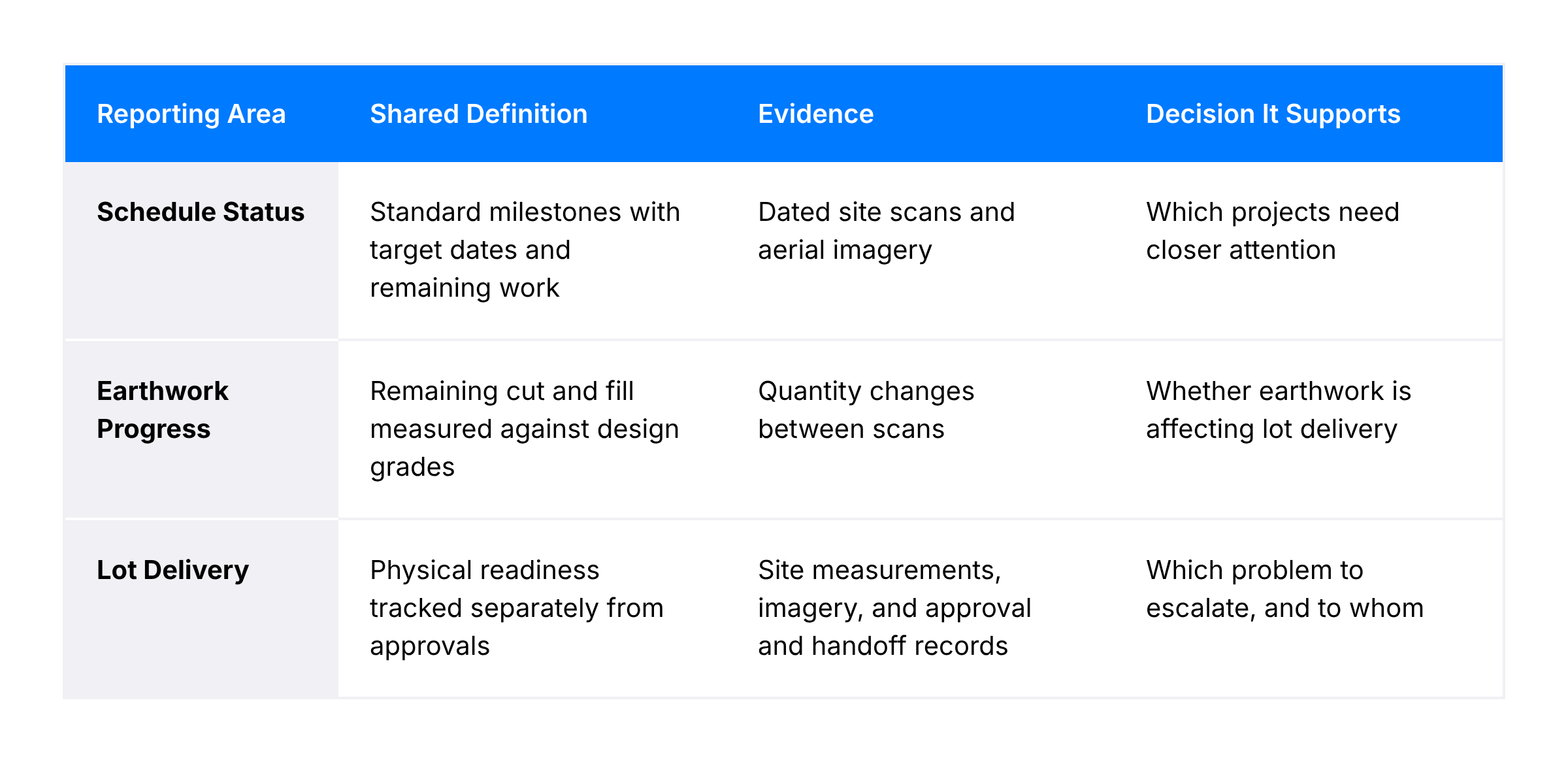
Two divisions may report similar completion percentages while measuring different scopes of work. To make schedule status comparable, each update should reference a standardized set of milestones across the portfolio, including target dates and remaining work, while documenting local dependencies within the shared reporting framework.
Regular TraceAir site scans give teams a dated view of physical progress, alongside the ability to quantify grading progress over time. Teams can easily identify stages of work from scan preview images of the portfolio-level dashboard, allowing them to further investigate into projects that may be at risk.
After a merger, divisions bring different contractor agreements, quantity sources, and measurement schedules into the combined portfolio. One division may operate primarily under fixed-price contracts, with less emphasis on quantity tracking for billing, while another may rely on detailed measurements to manage change orders. Both need visibility into remaining earthwork to understand potential impacts on lot delivery schedules.
TraceAir quantifies dirt moved between scans, calculates remaining cut and fill quantities, and compares current site conditions against design grade. This gives stakeholders involved the necessary data they need to make confident decisions at the executive level, as well as the project level. At Russell Ranch, regular grading measurements helped the team identify earthwork balance issues early enough to adjust grading plans before it resulted in major delays and rework.
Even across different contract types, this kind of insight allows leadership to assess actual earthwork progress on their own, providing instant clarity on if a project is scheduled to be delivered on time. For example, at Howard Hughes, Phoenix Division President Heath Melton overlays grading plans on current scans to show the corporate office where a project stands.
The same set of scans was also able to help verify a 100,000-cubic-yard change order with just a few clicks on the TraceAir platform. When the team went to measure the stockpiles on site themselves, they were able to validate that only a fraction of the claim was supported. This resulted in a substantial reduction to the proposed change order.
At Century Communities' Glennwood project, TraceAir's cut/fill analysis helped the team redistribute excess dirt across the site, avoiding the additional project costs associated with hauling material on or off site.
Divisions may use different criteria to report lots as finished. One division may consider a lot complete once grading and infrastructure work are finished, while another may require additional inspections, approvals, or a formal handoff before reporting it as ready for homebuilding.
TraceAir's site measurements and aerial imagery provide a consistent view of physical progress across communities. Combined with approval and handoff records, this helps leadership distinguish lots that still require construction work from lots awaiting administrative or regulatory approvals.
If two communities are both flagged for late lot delivery, a shared baseline can show whether one still has grading work while the other is waiting on municipal acceptance. Leadership then knows which problem to escalate and who can act on it.
Corporate and division land development leaders can begin by identifying the questions their combined reporting needs to answer: where horizontal construction is progressing as expected, which communities need closer attention, where lot delivery milestones are at risk, and what the organization can learn from divisions performing well.
They can then compare how each division defines schedule status, earthwork progress, and lot delivery, agreeing on shared reporting stages and the evidence needed to support each status while preserving relevant local milestones.
Bringing projects across the organization into TraceAir gives division teams access to the measurements, visuals, and collaboration tools they need at each stage of land development, while establishing one source of truth for portfolio-wide visibility.

See how meaningful work and construction site visibility help professionals build influence in land development and construction teams.

Homebuilder mergers can expose gaps in schedules, earthwork, lot reporting, and development obligations. See where land operations come under...
How TraceAir utilizes advanced drone technology and PPK processing to deliver accurate site intelligence for mega projects efficiently and quickly