Lot-by-lot grade verification

Call the surveyor when the lot is actually ready.

Lot Viewer checks every pad against design grade using the drone scan you already have — cut/fill balance, nine spot elevations, and a tolerance flag on every lot. Send the dirt crew where dirt is still needed, and the survey crew only where certification will pass.

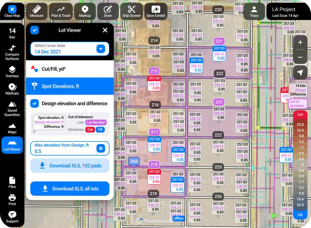
Lot Viewer: spot elevations and cut/fill balance on a graded lot
Next dayLot data delivery
3 cmAccuracy with every scan
9 pointsSpot elevations checked per pad
Every lotBatch-verified in one pass, not one trip at a time

The problem

A survey trip to a lot that is not ready costs you twice.

Pads get called in by feel — a walk-through, a phone call, whoever was on site last. The crew mobilizes, the lot fails certification, and the loop starts over. The vertical start date does not move with it.

Surveyors dispatched on a guess

A pad two tenths of a foot high fails certification. You pay for the trip, the rework, and the trip back — and the same crew gets called out six or seven times on one phase.

Dirt moved on the wrong lots

Without per-lot quantities, contractors work from memory. Balanced lots get touched, over-filled lots get missed, and nobody can point to a number.

Lot status lives in one person’s head

The superintendent knows which lots are close. The PM managing seven projects from two hours away does not, and neither does the civil engineer or the dirt sub.

Cut / fill balance

Know which lots are balanced before anyone moves dirt.

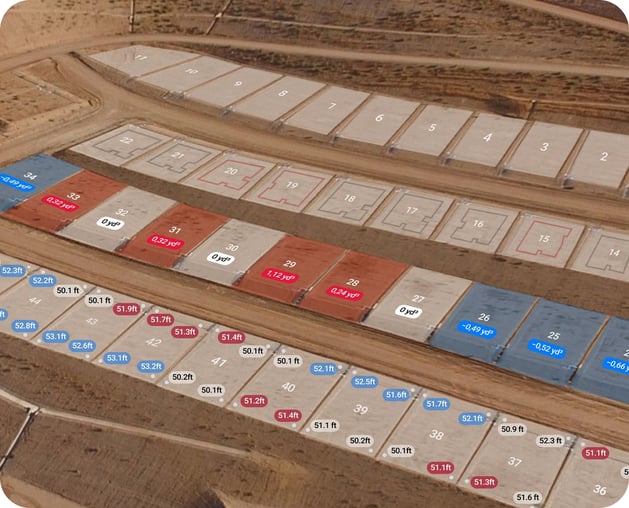
The moment a scan processes, every lot gets a color. Red needs cut, blue needs fill, white is balanced. Zoom in and each lot carries its own cubic-yard number, so the dirt contractor gets a quantity instead of a hand wave.

  • Per-lot cut and fill quantities in cubic yards
  • Site-wide color map that stays readable at any zoom level
  • Export every lot and its balance to XLS for the grading contractor
Lot Viewer cut/fill map: every lot colored red for cut, blue for fill, white for balanced

9-point spot elevations

Virtually grade stakes on every pad.

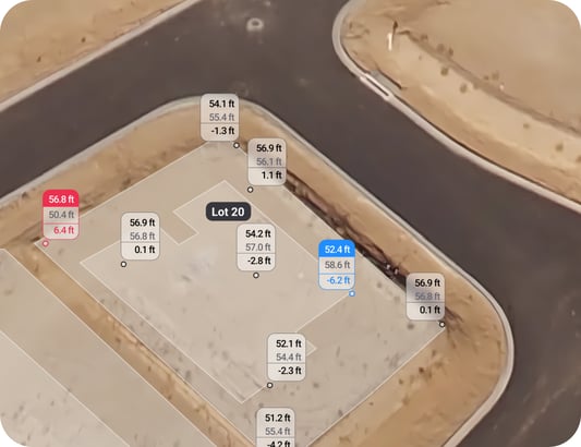
Lot Viewer pins up to nine elevations per lot — the lot corners, the building pad, and the center — and prints the design elevation and the difference right beside each one. It is the same check a crew would walk, without the walk.

  • Actual elevation, design elevation, and the difference at every point
  • Red points need cut, blue points need fill — no legend required
  • Move the points if your pads need a different pattern than the default nine
Nine spot elevations on a pad with design elevation and the difference at each point

Deviation & tolerance

Set the tolerance. Get the punch list.

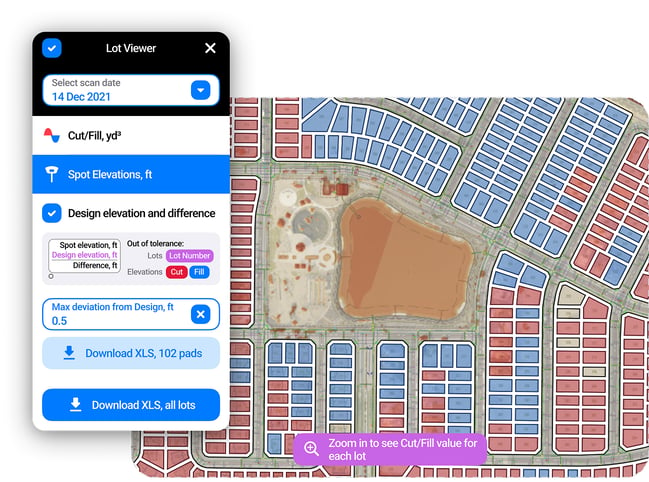
Enter the maximum acceptable deviation from design grade and Lot Viewer highlights only the lots outside it. Everything else drops back, so the crew works the lots that actually need correction instead of re-walking the whole phase.

  • Two exports: only the lots that failed, or the full site
  • Save any view as an exhibit with markups and share it without a login
  • Re-check against the next flight instead of taking someone’s word for it
Deviation tolerance filter highlighting only the lots outside the allowed grade deviation

See more

Teams already running lots this way

Mungo Homes customer story

Customer story

Mungo Homes sees faster lot turnover with Lot Viewer

“TraceAir is a great tool for accountability, verifying progress billing, & substantiating claims of onsite conditions at all stages of completion.”

Read the story  →
Master planned community development with TraceAir

Customer story

Why master planned community developers use TraceAir

Trusted by leading developers like Oxland and Johnson Development, TraceAir simplifies the most challenging projects.

Read the story  →

Ashton Woods customer story

Customer story

A lesson in scaling from 2023 Builder of the year

Relying on surveyors for something as simple as an elevation check is inefficient and a quick way to run through budget.

Read the story  →

Webinar

Watch a lot get verified, start to finish.

See Lot Viewer at work on a 500-lot demo site — turning on cut/fill, setting a deviation tolerance, reading nine spot elevations on a pad, and exporting the failing lots for the dirt contractor.

From the field

“We use Lot Viewer on all of our projects, and it’s quickly becoming our favorite tool within TraceAir. It allows our teams to pinpoint exactly which lots require attention and the specific areas in need of adjustments. This not only minimizes additional surveying expenses, but also accelerates project timelines overall with cleaner lot handoffs from site work contractor to vertical production.”

 Garth De Blasio, Manager of Land Development, Mungo Homes, Raleigh Division

Before scheduling a surveyor

Know which lots are ready for the next step

Book a demo and we will pull up a site like yours — cut and fill by lot, nine spot elevations per pad, and the tolerance filter that decides which lots the crew works first.