3 min read
A Decade of Innovation: TraceAir Turns 10
TraceAir is celebrating 10 years of transforming homebuilding and land development—from a startup with a bold idea to an award-winning platform...

3 min read
We’re excited to announce a new partnership and integration between TraceAir and Pipsy, making it easier than ever for homebuilders and developers to manage and visualize their communities.
With this integration, TraceAir’s aerial scans can now flow directly into Pipsy dashboards, giving master-planned community developers a complete view of their projects—from lot inventory and sales reporting to real-world, up-to-date site visuals—all in one platform.
TraceAir already gives you unmatched visibility into your job sites. With this integration, your scans don’t just live in TraceAir—they now work harder for your entire organization by extending into Pipsy.
Here’s what this means for TraceAir users:
With TraceAir and Pipsy connected, your scans now power both site intelligence and sales intelligence, helping you move projects forward with clarity and confidence.
Pipsy already streamlines how you manage lot inventory, sales reporting, and community analytics. Now, with TraceAir’s aerial scans layered into your dashboards, you gain a powerful visual layer that transforms how you plan, report, and sell.
Here’s how this integration elevates your workflow:
With TraceAir layered into Pipsy, you move beyond spreadsheets and status calls to a truly visual, data-driven way of managing your communities—all without leaving the tools you already know and trust.

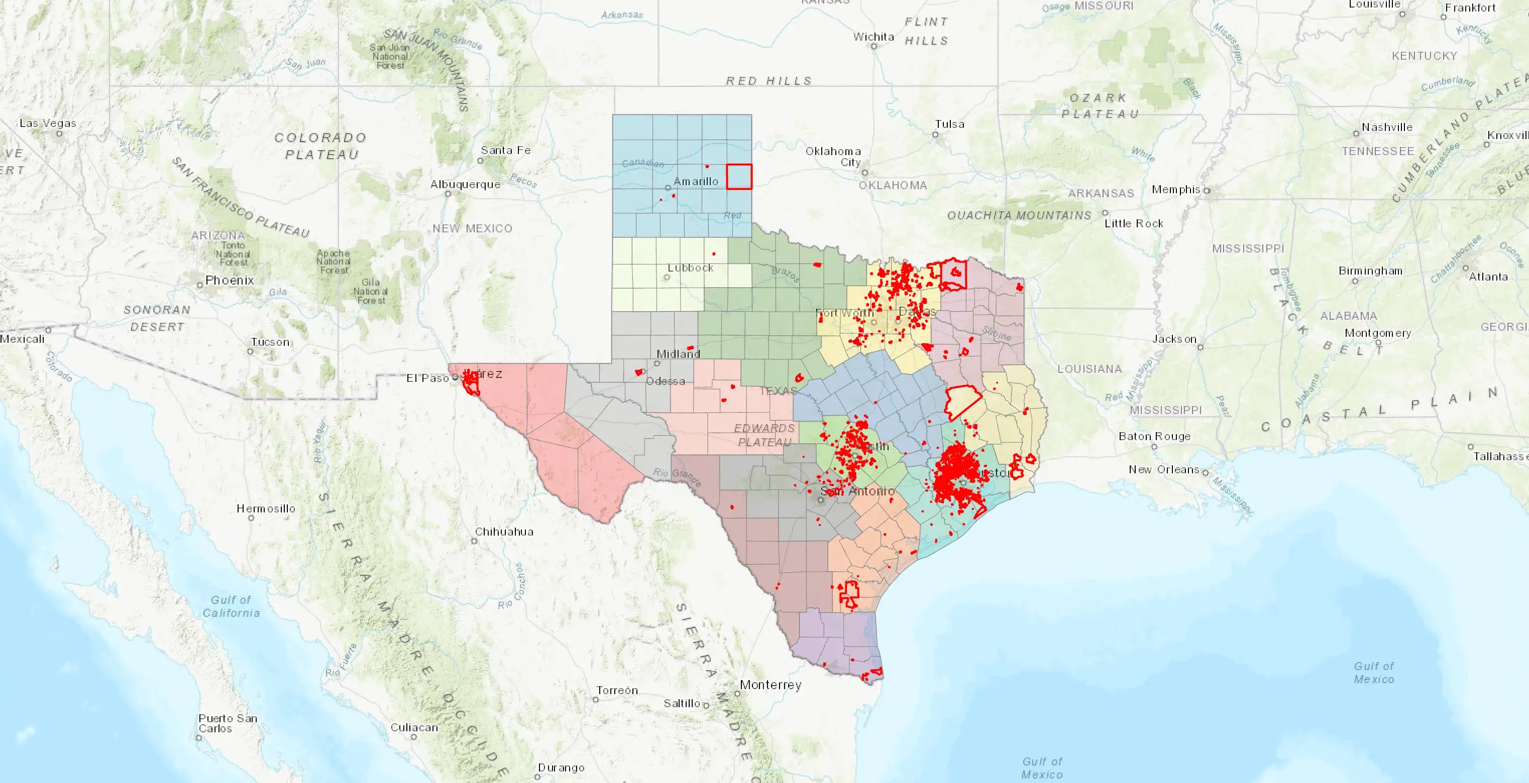
For Texas developers working within Municipal Utility Districts (MUDs), this integration delivers an even greater value.
Pipsy already streamlines MUD reporting by automating lot data, sales tracking, and development timelines. Now, with TraceAir’s aerial scans layered directly into Pipsy dashboards, you can:
This added transparency helps developers reduce reporting delays, eliminate manual documentation efforts, and deliver MUD updates with greater accuracy and confidence.
Pipsy delivers an AI-powered digital assistant tailored for master-planned community developers. The platform automates lot inventory management, sales reporting, analytics, and daily operations while unifying data across systems. With real-time updates and customizable tools, Pipsy helps land developers streamline operations across North America.
Features include advanced mapping, sales and inventory reporting, buyer engagement tools, and seamless CRM integration—all with zero-cost setup and no contracts. Pipsy gives developers the business intelligence they need to make faster, smarter decisions.
TraceAir users can reach out to their Customer Success Manager to enable the integration and start viewing their scans directly inside Pipsy.
Not yet capturing your sites with TraceAir? Enhance your Pipsy dashboards with high-resolution aerial imagery that gives your team full site visibility and the clarity to make faster, more confident decisions.

3 min read
TraceAir is celebrating 10 years of transforming homebuilding and land development—from a startup with a bold idea to an award-winning platform...
1 min read
Exciting news! We have partnered with PermitFlow, a leader in construction permit application and management software! This collaboration is set to...
1 min read
Jobsite coordination platform PLOT has joined forces with TraceAir to eliminate project miscommunications and enhance user experience with visual...