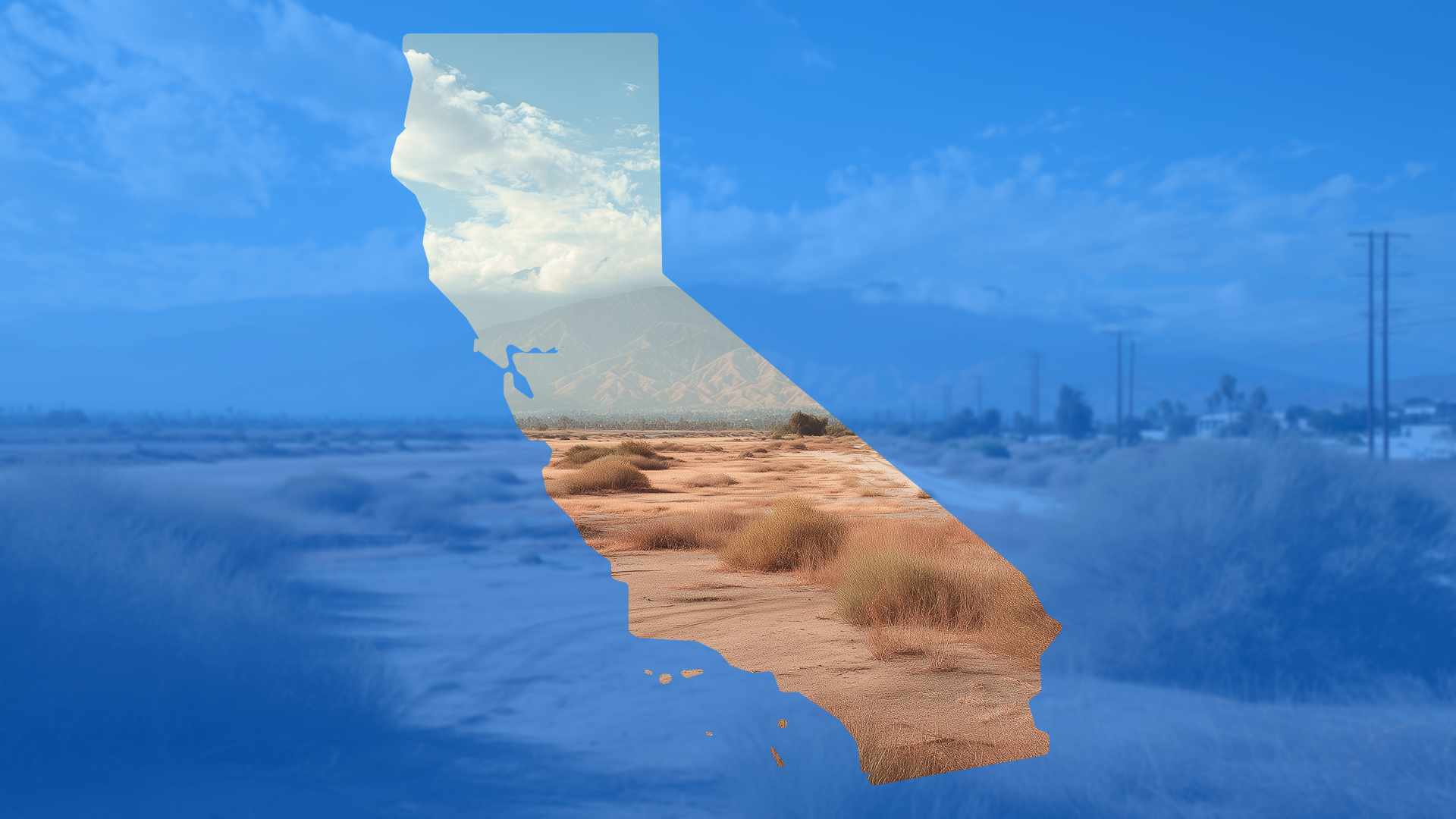
California land deals don’t sit still. By the time a parcel hits your radar, the entitlement path is already winding and the list of unknowns is longer than your runway. You need slope, drainage, and yield answers fast—before someone else ties up the site or your own pipeline stalls. Traditional surveys are thorough, but the wait drags. Weeks slip by while crews get scheduled, data gets processed, and decisions sit in limbo. Meanwhile, carry costs climb and the seller keeps taking calls.
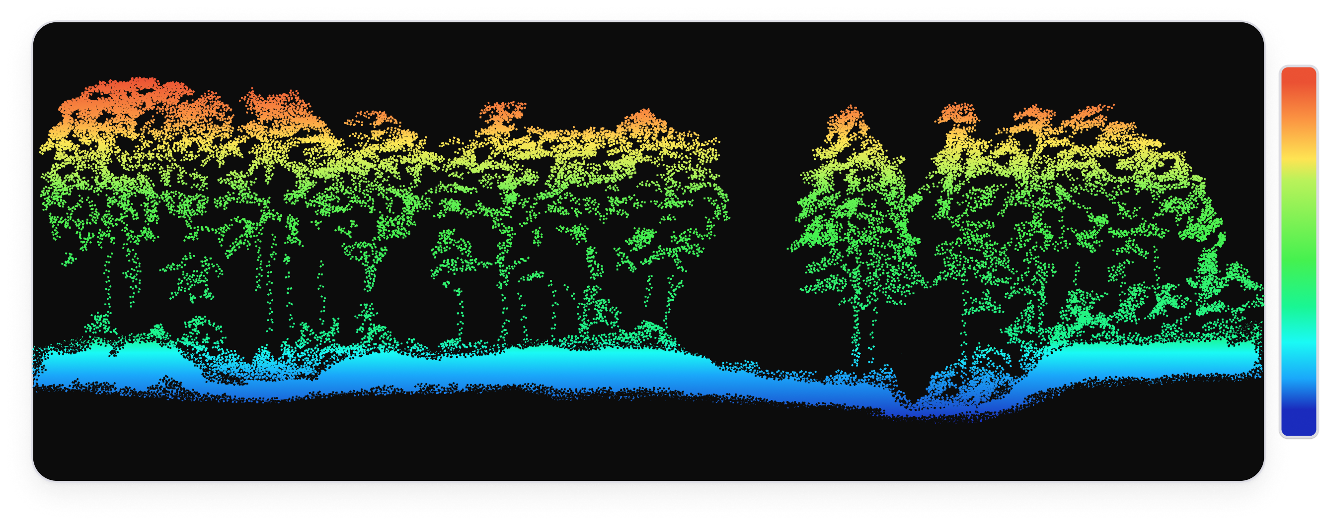
LiDAR changes the tempo. It can’t see through soil, but it does see the ground through vegetation, stripping away canopy to produce a clean ‘bare-earth’ model of the terrain. In California, that means you catch the microtopography—details that are easy to miss from ground level or orthos alone.
In California’s land race, the builder who evaluates sites fastest wins; LiDAR-derived, certified topo compresses weeks into days and exposes the terrain details that drive yield, grading, and drainage so acquisition teams can make confident, early calls.
👉 Learn more about LiDAR from TraceAir.
Why do traditional surveys slow California land decisions?
Because the clock moves faster than the queue. A competitive parcel doesn’t wait for mobilization windows, multi-day field work, and downstream processing. While you’re waiting on fundamentals—true ground, slope, drainage paths—capital idles and attention drifts. By the time files land, someone else may already be under LOI. The cost isn’t just the site you lose; it’s a pipeline that stalls every time you need basic answers to start the conversation.
What does LiDAR change in the first week?
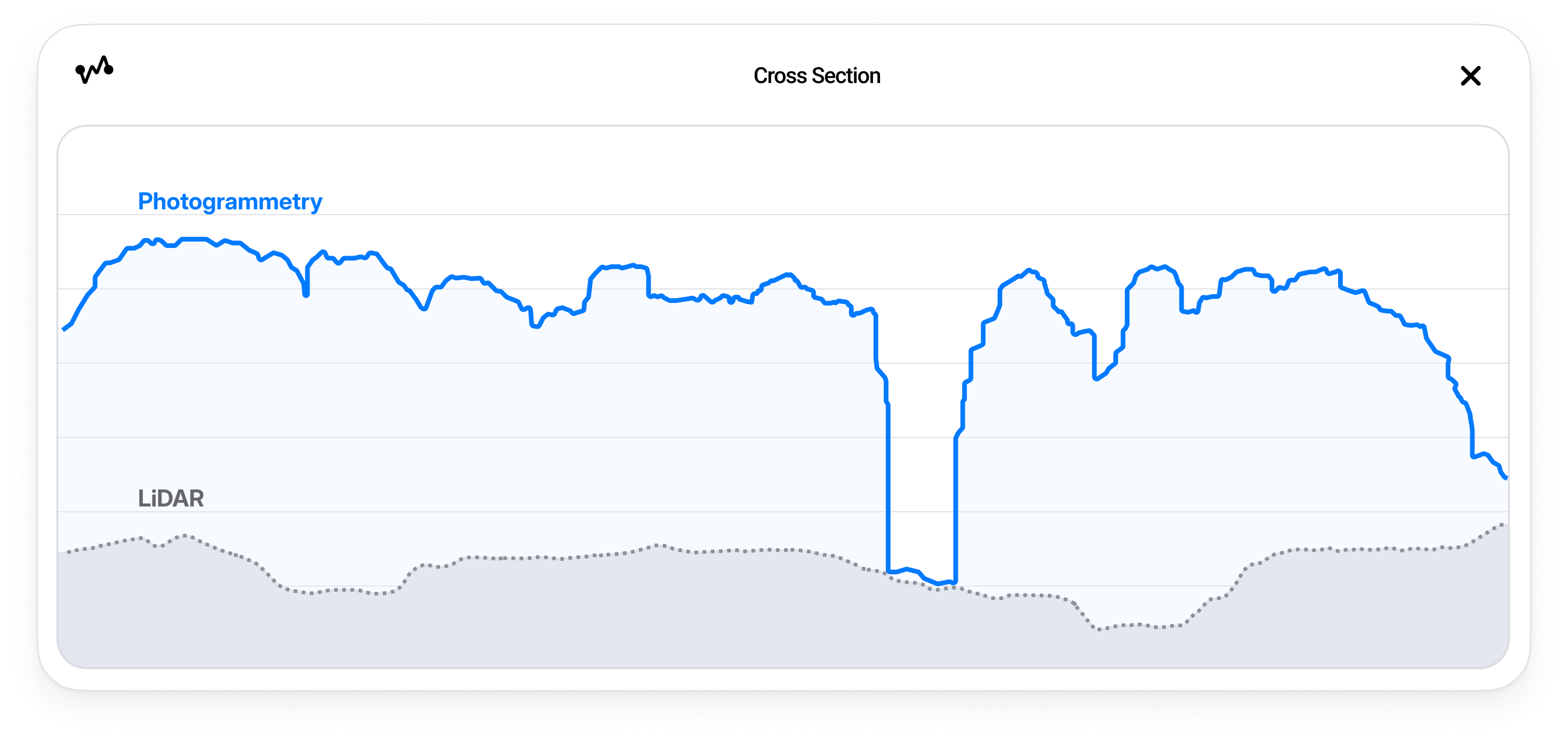
It puts a defensible bare-earth surface in your hands immediately. With canopy stripped and the ground resolved, acquisition teams can see the breaks that matter, sketch early grading ideas, and sanity-check yield before the field queue would even open. Speed only helps if it’s credible—this is speed that stands up in a meeting.
Brookfield Residential proved the point on a 70-acre Southern California project. Engineers initially projected a 40,000-cubic-yard dirt shortfall; LiDAR data revealed the true gap was more than 250,000. With TraceAir providing the topo and the grading contractor validating it, Brookfield reworked its plan before the shortage became a crisis.
“I am proposing using LiDAR for all our OG topography, regardless of project size, because it is significantly more accurate and faster than other methods.”
— Brian Mangano, Director of Regional Development, Brookfield Southern California
👉 Read the full customer story: Brookfield Residential’s Southern California Division’s Success with TraceAir and LiDAR
What does LiDAR actually surface in California?
With canopy peeled back, LiDAR reveals bare-earth features that shape feasibility: micro-ridges, saddles, and swales that concentrate runoff; subtle erosional gullies and headcuts after fire; and the geometry of alluvial fans and potential avulsion paths in SoCal foothills—key for understanding flood behavior on fan-fringe sites.
It also sharpens your view of terrain impacted by faults and landslides and helps you see linear breaks that geologists use—alongside field work and official mapping—to refine fault-adjacent risk. For Valley infill and ag conversions, statewide datasets capture levees, legacy pads, and field grading that affect cut/fill and drainage from day one.
None of this replaces official hazard designations or fault line setbacks, but it gets you to better questions (and faster go/no-go decisions) before you wait months for a full crew.
How do you turn a fast topo into a faster ‘go/no-go'?
You pressure-test reality, not assumptions. Start with quick yield and grading scenarios on top of the LiDAR surface; look for slope-limited pads, likely wall locations, and drainage conflicts that could move streets or reduce count. If the economics hold with terrain-true assumptions, you negotiate with confidence. If they don’t, you save weeks by walking early—with a clear rationale your team and partners can see.
How does LiDAR accelerate post-wildfire recovery and rebuilding in California?
After a burn, the question isn’t just “what’s there?”—it’s “what moved, and where will water go now?”
Hydrophobic soils shed water, small rills become gullies, debris piles into fans, and pre-fire drainage assumptions stop applying. A fresh LiDAR scan gives you the bare-earth record of changes like new headcuts, filled swales, or altered flow paths so you can re-shape drainage, adjust pads and roads, and plan debris-control measures before the first big storm tests the site.
When you can model these fixes on the same surface and show the outcome clearly, you convert a volatile landscape into decisions you can defend.
What is LiDAR (and what isn’t it) in California?
Use LiDAR and certified topography to pull clarity forward; then aim boundary/ALTA, subsurface investigations, and other specialty studies exactly where they resolve remaining risk. LiDAR does not replace a legal boundary survey or geotechnical work.
In California, TraceAir provides LiDAR and certified topographic deliverables through licensed surveyors, so the early clarity you rely on can also be stamped when needed.
How TraceAir turns week-one clarity into decisions.
TraceAir packages the clarity so decisions move. Licensed LiDAR in California delivers a highly detailed elevation topos that overlay projects—giving you accurate earthwork you can compare with grading plans. And with Layout Generator, land teams utilize slope and contour data to evaluate tracts, sketch roads, apply simple rules, and see lot yield in minutes.
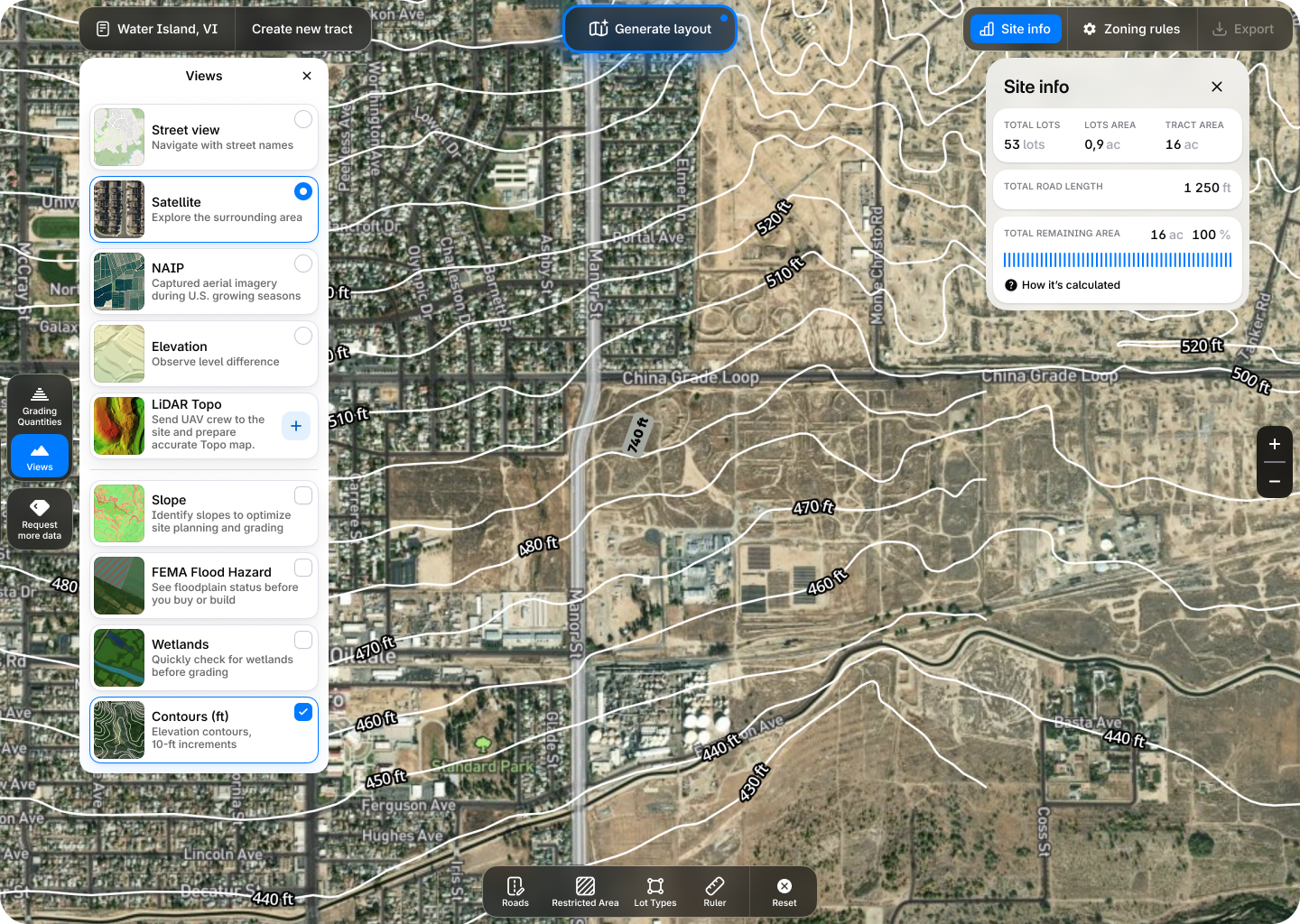
When slope bands, drainage paths, and early grading ideas live in the same, shareable platform, approvals stop being a narrative you have to sell and start being a picture everyone can read. And when you’re ready to step forward, export clean exhibits—terrain-true yield, slope/flow overlays, and council-ready maps—that helps partners and reviewers align quickly.
What changes in real terms for acquisition teams?
Evaluation cycles shrink from weeks to days. Internal reviews move faster because the story is visual and defensible. With the same headcount, your team compares more parcels per quarter, avoids dead-end sprints on sites that won’t pencil, and enters negotiations with fewer surprises hiding in the terrain. The practical outcome is simple: faster, more confident go/no-go decisions in California.
Winning California land deals isn’t about guessing faster; it’s about seeing sooner. When you have a defensible ground model in days, run yield and grading scenarios on top of it, and show terrain-true exhibits that anyone can follow, you replace slow, assumption-heavy cycles with decisions that hold up.